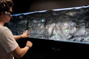
 The Virtual Outcrop Tour is an immersive application for collaborative discussions of outcrop data sets. It supports dynamic terrain rendering and the integration of large outcrop data sets, typically obtained by LIDAR scans. Geologists can interact with the system using gestures and speech. It also features out-of-core volume rendering of large seismic data sets.
The Virtual Outcrop Tour runs under the Windows operating system and it uses the following software packages itself:
- OSGEarth
- Octreemizer
- Kinect SDK
The Virtual Outcrop Tour is available for the members of the VRGeo Consortium.
Related Publications
- Jannik Fiedler: Multimodal Interaction Techniques for Scientific Data Visualization; Bachelor of Engineering Thesis, submitted to the University of Applied Sciences Duesseldorf on September 22, 2014.
“In this work, the focus lies on multimodal interaction techniques for scientific data visualization tasks. In particular, this work aims at evaluating if a synergistic fusion engine method is more effective and intuitive than other methods or none at all.”